| Home Location Map News History Village Hall Community Council Local Paths The College Sue Ryder Links Contact |
Recent Photographs
Throughout this site you will find some recent photographs, mostly via a link to view them from
within the relevant section of the text.
Below is a list of other photographs we have taken recently, with some brief information.
If you click on the thumbnail picture a new window will open and the image will load,
once the new window opens you will have the option to view the next photo or close it.
|
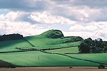
View of Binny Craig from the north.
View of Binny Craig showing the sloping landscape to the east (towards Ecclesmachan) and north |
| |
|
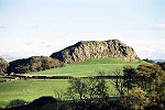
View of Binny Craig from the west
View of Binny Craig showing the fragmented cliff face, along the centre of the picture you can see a footpath that leads to Ecclesmachan |
| |
|
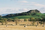
Closer view of Binny Craig from the west.
Similar to picture above but a close up view of the cliff face. |
| |
|
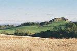
View of Binny Craig from the north-west.
Panoramic view of Binny Craig, showing pastures and recently harvested land. You can also see the Pentland hills clearly in the background. |
| |
|
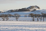
Winter view of Binny Craig from the north-west.
Panoramic view of Binny Craig from the same location as above, this time taken in the winter (2009). |
| |
|
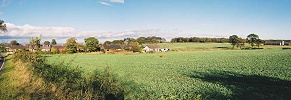
Threemiletown from the south-west.
Panoramic view of Threemiletown, showing what were the 'miners cottages' and where the No. 35 shale mine head was sited (just to the right of centre). |
| |
|
View of Ecclesmachan from the east.
In this picture you can see how Ecclesmachan is nestled at the west side of a thickly wooded valley. The church is in the centre of the picture, just behind a cottage. The college buildings can also be seen on a platform of rising land above and to the west. |
| |
|
View of Ecclesmachan from the west.
Centred on the village with the college in the foreground. Just behind to the left is Hillend farm, beyond that the landmarks of Greendykes (right) and Winchburgh shale bings (left). Winchburgh village is just in front of the Winchburgh shale bing. |
| |
|
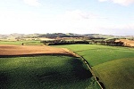
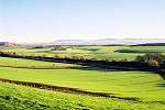
West from Binny Craig.
This view to the west from Binny Craig shows the rolling fields leading up to the Bathgate hills. |
| |
|
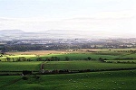
South from Binny Craig.
This view to the south could be clearer but you can see the land sloping gently towards Uphall and Houston Mains. Just left of centre is Houston House (white), beyond that is Livingston. |
| |
|
East from Binny Craig.
With the village (mostly obscured by trees) in the foreground, you can see the course of the burn and the old mineral railway threading away from it. To the right of centre is Newbigging farm, behind this you can see the enormity of the bing at Greendykes. Edinburgh is in the background recognisable by the familiar sights of Corstorphine Hill and Arthurs Seat. |
| |
|
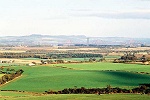
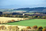
North-east from Binny Craig.
Again this view to the north-east could be clearer but you can see over Waterstone farm and Threemiletown to Hopetoun Estate and beyond to Fife. The familiar sights of the Forth road and rail bridges traversing the picture. |
| |
|
North-west from Binny Craig
Again with the hills on the north side of the river Forth in the background, this picture shows how the countryside rolls dramatically downwards towards the Forth. The building in the centre is Ochiltree Castle |
| |
|
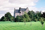
Ochiltree Castle.
A close-up of nearby Ochiltree Castle. |
| |
|
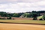
South-east from Tar Hill.
This picture shows the valley to the east and south of the village. In the centre is Newbigging Farm, on the left side is Greendykes shale bing and on the horizon the Pentland hills. In the shadow of the treeline running across the picture is the burn and what remains of the old mineral railway embankment. |
| |
|
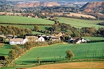
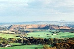
South-west from Tar Hill.
This picture, taken in the autumn, shows Ecclesmachan from Tar Hill. The treeline across the picture is that of Binny Estate. The buildings to the right above the village is Oatridge Agricultural College, overlooked by the familiar 'bump' of Binny Craig. |
| |
|
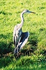
Local wildlife - Heron.
This poor bird had an accident and damaged a wing. Happily though, after a day or so rest at the bottom of Tar Hill, it flew again and still visits the village regularly. |
| |
|
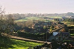
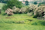
Ecclesmachan Burn - Situation Normal.
A picture taken in the late spring of 2002. You can see the course of the little burn, which normally has very little flow. |
| |
|
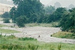
Ecclesmachan Burn - Water, Water Everywhere.
This picture was taken on 30 July 2002 (during a brief lull in the rain), the burn rose right over the banks and flooded the base of the valley. |
| |
|
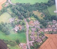
Ecclesmachan from the air.
Aerial picture of the village taken from a Cessna (G-GBLP) flying overhead at 1,500 feet. My thanks to Mr. B Farish for permission to use it here. |
| |
| Copyright © 2011: Ecclesmachan.org.uk |